WCAG 2.1 AA accessible edition

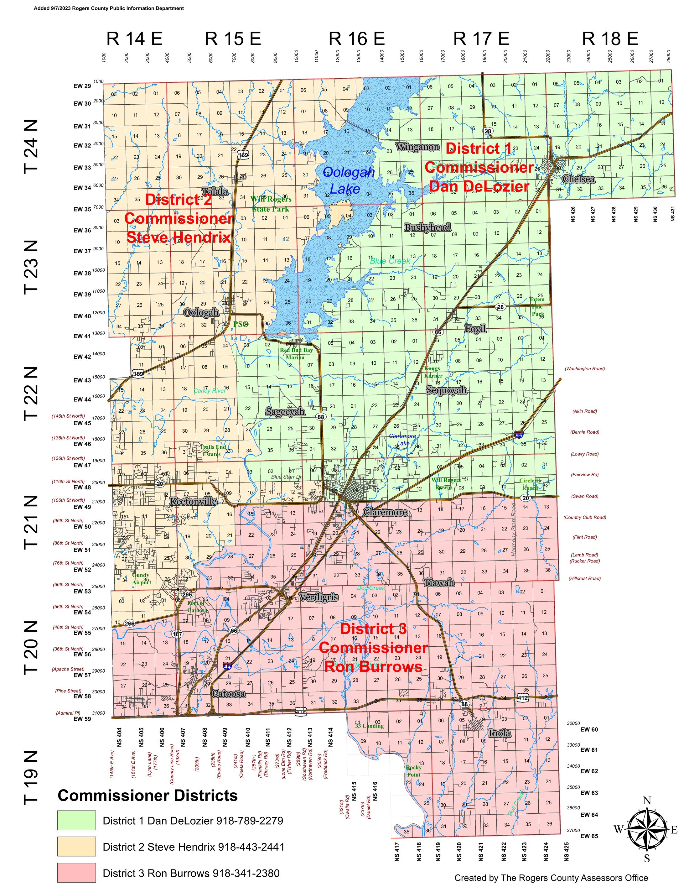
An accessible version of the Rogers County Commissioner District map

Text alternativeEvery visual fact on the map is also written as text below.
Not color-dependentDistricts are also shown with pattern and text, for colorblind users.
Keyboard & screen reader friendlyEvery control works with Tab, Enter, and arrow keys.
Zoomable map

View the original district map

This is the county's original map image, embedded at high resolution so it can be enlarged without blurring. Use the buttons below, your keyboard (+ / - / 0 while focused on the map, or arrow keys to pan), or a two-finger pinch on a touchscreen. If you don't need the visual map, skip ahead to the text-based lookup tool, which contains the same information.

Text-based lookup

Find your district by community

This tool gives the same result as reading the map, without needing to see or interpret it. Choose the town, lake, or landmark nearest you.

Selecting a place shows its commissioner district below.

Full text alternative

Commissioner district details

Each district below is identified by name and pattern, not color alone, so it remains distinguishable for colorblind users and in grayscale printing.

District 1 · Green, diagonal-stripe pattern

District 1

Commissioner Dan DeLozier

918-789-2279
Covers roughly Northeastern Rogers County — townships 24N–21N, ranges 16E–18E.
Communities & landmarks Chelsea, the eastern edge of Winganon, Bushyhead, Foyil, Sequoyah, Sageeyah, Totem Pole Park, Will Rogers Downs, Claremore Lake, Red Bud Bay Marina, Kongs Korner, Circle H Ranch, and Claremore north of Highway 20.

Boundary note: the district's western edge runs along the eastern shore of Oologah Lake and the Range 16E line; its southern edge runs along State Highway 20 and cuts through northern Claremore. Winganon itself is split by this boundary — the town's east side is in District 1, its west side is in District 2. Claremore is split three ways between all three districts; see District 2 and District 3 for the rest of the city.

District 2 · Gold, dotted pattern

District 2

Commissioner Steve Hendrix

918-443-2441
Covers roughly Northwestern Rogers County — townships 24N–21N, ranges 14E–15E, plus a smaller pocket in the southwest near Highway 266, plus the area west of downtown Claremore.
Communities & landmarks Talala, Oologah, Keetonville, Trails End Estates, Gundy Airport, most of Winganon (west side), the area around Will Rogers State Park, and Claremore west of downtown.

Boundary note: this district wraps around the western and northern shore of Oologah Lake and has a second, non-adjacent area near the Port of Catoosa / Highway 266 in the southwest corner of the county. It also includes a separate, non-adjacent pocket west of downtown Claremore — Claremore is split three ways between all three districts.

District 3 · Rose, vertical-line pattern

District 3

Commissioner Ron Burrows

918-341-2380
Covers roughly Southern Rogers County — townships 21N–19N, ranges 14E–18E.
Communities & landmarks Catoosa, Port of Catoosa, Verdigris, Tiawah, Inola, Rocky Point, 33 Landing, and Claremore south of Highway 20.

Boundary note: the district's northern edge runs along State Highway 20 through southern Claremore, then east along the Bird Creek / Verdigris River corridor toward Inola. Claremore is split three ways between all three districts; see District 1 and District 2 for the rest of the city.

Commissioner districts, contacts, and communities — Rogers County, Oklahoma (map added 9/7/2023, Rogers County Public Information Department)
District Commissioner Phone General area Communities & landmarks
District 1 Dan DeLozier 918-789-2279 Northeast county Chelsea, Winganon (east side), Bushyhead, Foyil, Sequoyah, Sageeyah, Totem Pole Park, Claremore (north of Hwy 20)
District 2 Steve Hendrix 918-443-2441 Northwest county Talala, Oologah, Winganon (west side), Keetonville, Trails End Estates, Gundy Airport, Claremore (west of downtown)
District 3 Ron Burrows 918-341-2380 South county Catoosa, Port of Catoosa, Verdigris, Tiawah, Inola, Rocky Point, Claremore (south of Hwy 20)
Source

Where this data comes from

All district, contact, and geographic information above was read directly from the Rogers County Assessor's Office district map, published by the Rogers County Public Information Department and added 9/7/2023 — rogerscounty.org/DocumentCenter/View/123/District-Map-PDF. This accessible edition does not alter district boundaries, contacts, or figures from that source.

Legal note: this page is an independently produced accessible rendition of the county's map for convenience and compliance purposes. District boundaries are described at the community/town level; they are not a substitute for the section-level legal description. For a precinct-exact determination (e.g., for voting or legal purposes), confirm with the Rogers County government or the original PDF. If you encounter an accessibility barrier on this page, please contact the county's ADA coordinator so it can be corrected.